|
|
|
Alaskan
Aerial Survey Expedition
The first Alaskan
Aerial Survey Expedition was conducted between June 6 and September 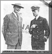 24, 1926, headed by
Lieutenant Ben H. Wyatt of NAS San Diego. The preparations for the expedition
were largely made at San Diego, although the staging area was
Seattle .The last elements of the Alaskan Aerial
Survey Expedition departed Seattle for Alaska. The expedition, under command of Lieutenant B. H. Wyatt, was
composed of the tender Gannet (AM 41) the barge
24, 1926, headed by
Lieutenant Ben H. Wyatt of NAS San Diego. The preparations for the expedition
were largely made at San Diego, although the staging area was
Seattle .The last elements of the Alaskan Aerial
Survey Expedition departed Seattle for Alaska. The expedition, under command of Lieutenant B. H. Wyatt, was
composed of the tender Gannet (AM 41) the barge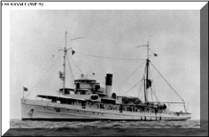 YF 88 housing a photo lab and mobile base for the expedition,
and three
Loening amphibians. Two of the airplanes were OL-4s equipped
for aerial photography. The third was an OL-2 which served as a standby plane for searching in
case one of the photography planes was forced down. It was also the radio plane
for the expedition.
YF 88 housing a photo lab and mobile base for the expedition,
and three
Loening amphibians. Two of the airplanes were OL-4s equipped
for aerial photography. The third was an OL-2 which served as a standby plane for searching in
case one of the photography planes was forced down. It was also the radio plane
for the expedition.
|
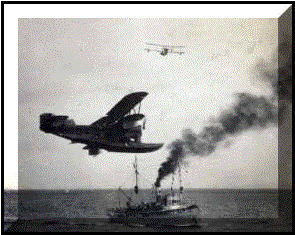
The Gannet! San Diego, prior to the Alaskan Survey. (Built by Todd, New York. Laid down 1 November 1918, launched 19 March 1919, commissioned 10 July 1919. Assigned to seaplane duties immediately upon completion, but also served in towing, salvage, transport and general support duties. Designated "minesweeper for duty with aircraft" 30 April 1931. Redesignated AVP8 22 January 1936. Torpedoed and sunk by U-653 off Bermuda 7 June 1942 while searching for a torpedoed freighter.) |
The w ork of the expedition, which
extended through the summer and into September, was performed in cooperation with the
Department of the Interior for early aerial mapping of Alaska.
The
purpose of the expedition was survey of Southeast Alaska for the Department
of the Interior for use with the investigation of resources of
that region.
During the summer over 15,000 square
miles
were mapped.
ork of the expedition, which
extended through the summer and into September, was performed in cooperation with the
Department of the Interior for early aerial mapping of Alaska.
The
purpose of the expedition was survey of Southeast Alaska for the Department
of the Interior for use with the investigation of resources of
that region.
During the summer over 15,000 square
miles
were mapped.
The Alaskan Survey
which began in 1926 was completed in 1929 under the command of Lieutenant Commander A. H. Radford
(Rear Admiral - whose
distinguished naval career 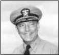 cumulated
in service
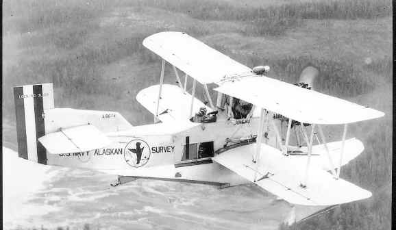
as Chairman of the Joints Chiefs of Staff l953- of Aircraft Squadrons, Battle Fleet. The winged seal insignia designed by Lieutenant Emile Chourre was painted
was painted on the four Loening Amphibians (four
new Wasp powered OL-8As) of the S
cumulated
in service
as Chairman of the Joints Chiefs of Staff l953- of Aircraft Squadrons, Battle Fleet. The winged seal insignia designed by Lieutenant Emile Chourre was painted
was painted on the four Loening Amphibians (four
new Wasp powered OL-8As) of the S urvey which left San Diego on May 15. Each
aircraft bore a name Juneau, Ketchikan, Petersburg,
and Sitka & bore a large Winged
Seal Insignia special id. VJ-1F l957) of Aircraft Squadrons, Battle Fleet.
The winged seal insignia operated the Fourth Alaskan Survey - 1934
with OL-9 aircraft. (Note Radford was VJ-1 Squadron Skipper when they embarked
on the Yorktown for Pearl 6 Jun 40.)
urvey which left San Diego on May 15. Each
aircraft bore a name Juneau, Ketchikan, Petersburg,
and Sitka & bore a large Winged
Seal Insignia special id. VJ-1F l957) of Aircraft Squadrons, Battle Fleet.
The winged seal insignia operated the Fourth Alaskan Survey - 1934
with OL-9 aircraft. (Note Radford was VJ-1 Squadron Skipper when they embarked
on the Yorktown for Pearl 6 Jun 40.)
A U. S. 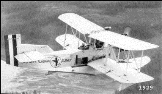 Navy Loening OL-8A called the
"Juneau" flown by Lieutenant Commander Arthur W. Radford on the Alaskan Aerial Survey
Detachment in Southeast Alaska in 1929. Radford went on to become Admiral
Radford, Chairman, Joint Chief of Staff.
The USS GANNET with a covered barge in tow
left from Puget Sound Navy Yard for the survey.
Lieutenant Commander Radford, who commanded the survey, was
Operations Officer of NAS.
Navy Loening OL-8A called the
"Juneau" flown by Lieutenant Commander Arthur W. Radford on the Alaskan Aerial Survey
Detachment in Southeast Alaska in 1929. Radford went on to become Admiral
Radford, Chairman, Joint Chief of Staff.
The USS GANNET with a covered barge in tow
left from Puget Sound Navy Yard for the survey.
Lieutenant Commander Radford, who commanded the survey, was
Operations Officer of NAS.
|
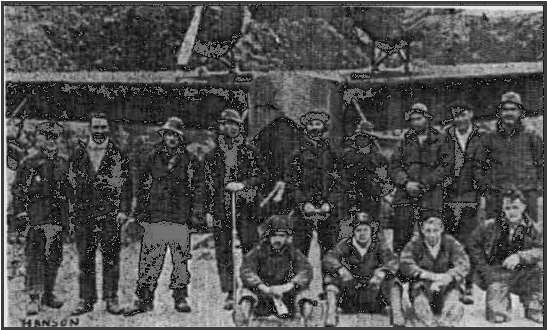
THE
GOOD (?) OLD DAYS With getting ready to celebrate 20 years of continuous
service as the records of the past years have been getting a Going over.
Here we have two photographs taken during the Alaskan survey, which the
squadron conducted in 1934. This survey and others similar to it were
partly responsible for the Navy being able to establish bases In the
Aleutians and Alaska for the war which has just ended. In the group photo the chief on the extreme left is
Hanson, ACCM, who is still in charge of the carpenter shop of this
squadron. The aircraft, which is being hoisted aboard the tender, is an
OL-9, which is the forerunner of the present day J2F's which the Navy
uses. |
THEY
MAPPED ALASKA'S WILDS
Thirty-five years ago, an expedition put out from San Diego to spend the
summer making aerial maps of unexplored territory in
Alaska.The following story of the adventure was written by Lt. Ben H. Wyatt,
senior Naval Aviator and expedition commander. It has been condensed only slightly from the way
it appeared in the February 1927 issue of World’s Work magazine.
The portions appearing in standard type are
those which were published in 1927. The paragraphs in hold face were writ ten in
this, the Fiftieth Anniversary Year of Naval Aviation, by the same author, now
Commodore Ben Wyatt, USN, Retired. The bold face paragraphs may he construed as
his afterthoughts of the expedition.
By Commodore Ben H. Wyatt, USN, (Ret.)
As
THE NOISELESS snows of Time have descended upon the eternal mountains of Alaska,
so has the inaudible foot of the Past left imprint upon our memory, which
remains as fresh as the newly fallen snows of today on those same Alaskan peaks
which challenged our efforts of yesteryear.
‘Tis
said that "the past is the prologue of Tomorrow." Since we are
celebrating the 50th Anniversary of Naval Aviation, we beg your indulgence for a
short review of those early years, so that the picture of the future may be
better developed.
The
day was gray, the clouds were low, a dead calm prevailed, when on the morning of
May 24, 1926, three heavily laden planes attached to the Aircraft Squadrons,
Battle Fleet, took the air. Swinging over the Naval Air Station at San Diego,
the planes, with their powerful motors thrumming a song, turned, assumed a
cruising formation, and headed northward, Alaska bound. They were off, embarked
on a photographic mission, the equal of which had not, as far as is known, ever
been attempted by the air forces of any nation-to survey from the air
America’s last frontier, the hitherto unexplored and almost inaccessible
islands and portions of the mainland of southeastern Alaska.
 Alaska has long been famed in fiction and picture as
the land of ice and a land of saloons, and gold, and snow-the land, which has
for ages stood aloof and ignored the pleas, the struggles, and the conquering
aspirations of man. Its towering peaks, covered with the snows of ages, have
stood since time immemorial, forbidding man and his science the right to
conquer.
Alaska has long been famed in fiction and picture as
the land of ice and a land of saloons, and gold, and snow-the land, which has
for ages stood aloof and ignored the pleas, the struggles, and the conquering
aspirations of man. Its towering peaks, covered with the snows of ages, have
stood since time immemorial, forbidding man and his science the right to
conquer.
Those
words-"The Frozen North!" -flashed through my brain when I was
notified by the Navy Department that I had been placed in command of an
expedition to fly into that land of romance for the purpose of making an aerial
photographic map of its topography. At that time, Alaska was to me the Alaska of
Robert W. Service, a land of saloons, and gold, and "ladies" known as
Lou.
Immediately upon receipt of orders to command the
expedition, I set about to organize it. There was much to be 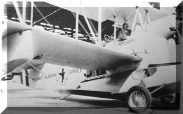 done. First and foremost, there were planes to be
selected; then cameras to be obtained, a tender to be found, and highly skilled pilots and personnel
chosen and trained. Realizing that we should have to fly over foreign territory, we had
to obtain permission from the British Embassy for the planes to operate in
Canadian waters. Since much of the territory over which the planes would be operating was uninhabited
and unexplored, it was necessary for us to gather information as to the location
of probable bases as well as to cache supplies, food, gasoline, and oil at
selected points. All of this and much more had to be arranged in a limited
period of time.
done. First and foremost, there were planes to be
selected; then cameras to be obtained, a tender to be found, and highly skilled pilots and personnel
chosen and trained. Realizing that we should have to fly over foreign territory, we had
to obtain permission from the British Embassy for the planes to operate in
Canadian waters. Since much of the territory over which the planes would be operating was uninhabited
and unexplored, it was necessary for us to gather information as to the location
of probable bases as well as to cache supplies, food, gasoline, and oil at
selected points. All of this and much more had to be arranged in a limited
period of time.
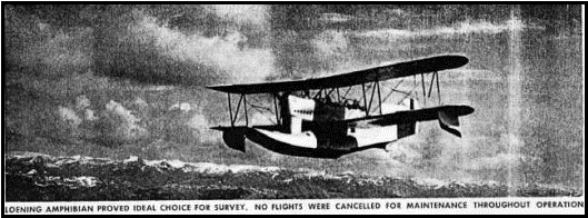
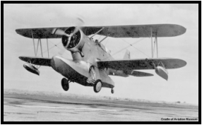
The type of plane chosen was the Loening Amphibian, which represents the very latest development in aircraft. This plane was chosen because of its ability to land either on the water or on the land. If the pilot desires to land on the land, he operates a lever, which lowers a pair of wheels, and the plane becomes a landplane. The operation of raising and lowering the wheels reminds one of the folding beds used in apartments.
This
type of plane was chosen not with the idea that it would be possible to land in
southeastern Alaska as a landplane, but rather with the thought that it could be
landed on the water and then by lowering the wheels the plane could be taxied
out of the water on to the beach where it could be securely tied down and
otherwise protected from the severe storms which sweep up and down the narrow
channels with hurricane-like force.
The
wisdom of our selection of this plane was brought forcibly to our attention
during our first month’s operations, when a very severe storm caused much
damage to fishnets and small boats throughout the entire Alexander Archipelago.
No seaplane could have possibly withstood the storm, while moored out.
 As we look back 35 years and review the Loening
Amphibian which we used, our present day aviators may scoff at the crudeness of
our equipment. Certainly no seaplane of any year could have withstood the storms that swept the seas and
inlets during our stay in Alaska. No land areas were available upon which a
"landplane" could operate.
As we look back 35 years and review the Loening
Amphibian which we used, our present day aviators may scoff at the crudeness of
our equipment. Certainly no seaplane of any year could have withstood the storms that swept the seas and
inlets during our stay in Alaska. No land areas were available upon which a
"landplane" could operate.
Today with our "push button" practices,
with time and effort-saving devices, 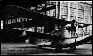 we are far removed from the hand crank, which lowered
and raised the wheels of our planes. Though hand cranks we used, our tempers were not
abused-and our wheels were down when they should be down, and up when landing on
the sea. The
altitudes at which today’s planes fly and the range of the cameras bear the
same relationship between the hand crank of yesterday and the push button
miracles of today’s marvels. We of the Alaska Survey in our days were pioneers
in our field.
we are far removed from the hand crank, which lowered
and raised the wheels of our planes. Though hand cranks we used, our tempers were not
abused-and our wheels were down when they should be down, and up when landing on
the sea. The
altitudes at which today’s planes fly and the range of the cameras bear the
same relationship between the hand crank of yesterday and the push button
miracles of today’s marvels. We of the Alaska Survey in our days were pioneers
in our field.
Another
new feature of this plane is the fact that it is equipped with an inverted
Liberty motor. Instead of the motor being placed in the normal upright position,
it is placed upside down. That is, the pilot, instead of looking out over the
top rows of cylinders, is looking over the crankcase. The advantages claimed for
this motor are additional horsepower, owing to better cooling and lubrication;
better vision for the pilot; and a higher application of the thrust, since the
propeller is mounted on the crankshaft, which in the inverted motor is near the
highest point.
The cameras chosen were of the type known as the "Tri-Lens" and were invented by Maj. Bagley, formerly of the Interior Department. This camera, as the name implies, has three lenses, which
operate simultaneously, giving three exposures. The
center picture is a true vertical; the other two are taken at angles of 35
degree on either side. In order to use the two side pictures, it is necessary
first to transform them so as to give a projection in the vertical plane. For
this purpose special transformers have to be built for each camera. The camera
uses film, which is made in rolls six inches wide, and an average of 380 feet
long. Alaska is far removed from an aviation base, so it was necessary to find a
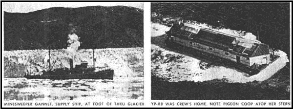
tender to serve the planes and pro vide supplies for the base. The USS Gannet,
a vessel of the minesweeper class, was designated to do this duty by Adm.
Charles F. Hughes, then Commander-in-Chief of the Battle Fleet. Since it was not
deemed feasible for the Gannet to
quarter the aviation detachment as well as her own crew, some means of
quartering these men in the vicinity of the airplane base was necessary. After
considerable thought and worry, the plan of quartering them ashore in tents was
abandoned because of the torrential rains and cold. Instead of tents we used a
floating, covered barge, 110 feet long and 40 feet wide. This barge was fitted
with sleeping quarters for the crew, a galley where the food was prepared, a
motor over-haul shop for the care of the plane motors, a photographic laboratory
where the film was developed immediately upon the return of the planes from a
mapping flight, radio equipment for communicating with the planes and tender
when they were away from the base, hot and cold showers, a barber shop, and all
the necessities of life as well as many of their discomforts.
The
opinion that the barge was a fine place to live in was jointly held by the crew
and the mosqu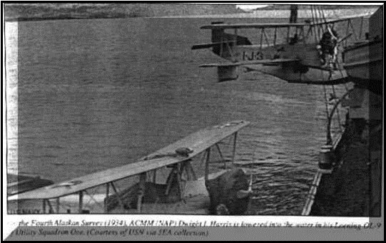 itoes.
The covered barge YP-88 met with much opposition from
the marine experts and particularly the marine pilots of Alaska. Having had a
limited sea-going experience in World War I aboard destroyers, I shared
this concern with our critics. After a thorough investigation, I made my concern
known to Admiral Hoogeworth, Commandant of the Bremerton Naval Shipyard where
the barge was being prepared. I also secured the services of the man whom I
believed to be the best Alaskan pilot available.
itoes.
The covered barge YP-88 met with much opposition from
the marine experts and particularly the marine pilots of Alaska. Having had a
limited sea-going experience in World War I aboard destroyers, I shared
this concern with our critics. After a thorough investigation, I made my concern
known to Admiral Hoogeworth, Commandant of the Bremerton Naval Shipyard where
the barge was being prepared. I also secured the services of the man whom I
believed to be the best Alaskan pilot available.
The
thorough work of the shipyard and the able handling by our pilot and Captain
Spears of the Gannet saw us through to the successful completion of our task
without incident. The barge YP-88 was mostly referred to as the "Pigeon
Roost-" Although we had radio sets in those days, they were heavy and
bulky. Since we had to get as much altitude as possible with our planes, we had
to limit their load.
Communication
by radio between two points at sea level in mountainous areas was and is very
erratic owing to intervening mountains, which trapped the passage of the radio
wave. Hence we carried homing pigeons in our planes for release in case of
emergency.
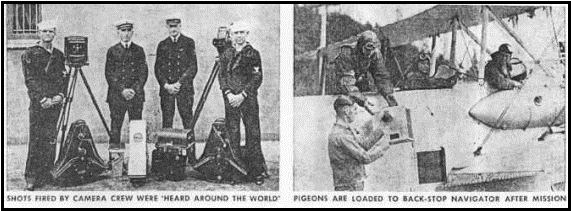
The
"Pigeon’s Roost" was on the upper after section of the roofline of
the barge as shown in the photos. Except for trial flights, the pigeons were
used on only one occasion.
We
were completing our survey for the day and were on our eastward run. In our
Flights we seldom saw any evidence of human beings or habitation. However, as we
turned westward to return home we saw someone on the leeward shore of the lake
over which we were flying. We landed and taxied to the beach. There on the shore
with a canoe snugly moored to her trim waistline was a young lady who presented
a picture requiring the talent of a master painter to match her beauty and
harmonious setting of the scene before us. Unfortunately at this moment my
attention was diverted from the shore by the disembarking movements of the
bachelor Lieutenant in the rear seat behind me.
"My
name is Whitehead, what’s yours, and what are you doing here?"
"Ketchin
foxes or any animals fit to be had . . . - Kin I do much for you folks?"
she answered. "Well, we thought maybe you were in trouble and needed our
help. Where do you live?" "Over a distance there, five miles or more,
t’other side of the lake." Dick, with a twinkle in his eyes, reluctantly
said to me, "Ben, could we tow her home if she wishes?" "Sure we
could," I said. "Load her in your seat, then you and the traps get
into the canoe. Tie it astern, and off we’ll go!"
And
this was the only use of our pigeons; to report our delay.
The organization of the expedition comprised three units-the planes, the tender, and the covered barge. The force was entirely self-supporting as well as a mobile, sea-going unit. With the Gannet as a means of transporting supplies from their permanent source and of towing the barge to
isolated sections, the only requirements for a suitable
base were an
anchorage protected from the wind and sea, a sufficient quantity of fresh water
for use in photographic work, and a beach upon which to run the planes out of
the water.
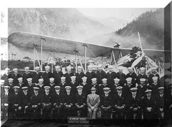
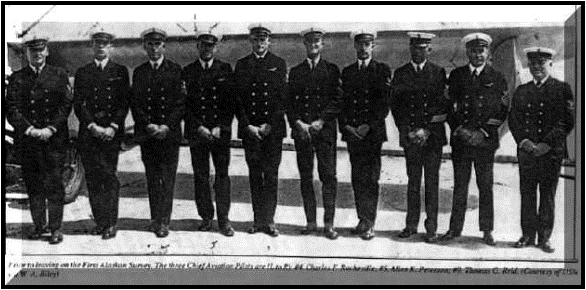
The
personnel comprised 12 officers and 100 men. The aviation detachment numbered
seven officers including five pilots, a flight surgeon, and a supply officer,
and 40 enlisted men of various ratings. The Gannet, under command of Lieutenant William K. Spear, carried her
regular crew of five officers and 60 men.
At
Seattle, after a 1300-mile journey up the coast, the planes and the Gannet
made a rendezvous at the Navy Yard in Puget Sound. Here the covered barge
was awaiting the arrival of the expedition. Aviation stores, the 40 men of the
aviation detachment with bag and baggage, commissary equipment, fresh water, and
provisions were loaded helter-skelter aboard the barge-and the long journey to
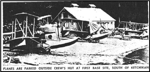
Alaska began. We were finally headed for Ketchikan, our first operating base.
Ketchikan is built on the side of a mountain and on piling over the water. Most
of the main thoroughfares are nothing more than docks built up in the manner of
streets. The entire business district is on piles with the floor a few feet
above high water.
As
we circled the city preparatory to landing in the channel—which was barely
wide enough to turn the planes in—it appeared that the entire population of
5,000 inhabitants was lined up on the docks and hillsides to give us a welcome.
As soon as we landed, we were met by so many small boats that it was necessary
for me to stop my motor and direct one of the boats to clear the way ahead, so
that we could go on to the beach. The boat led us into the dock and pointed to
an area covered with water and told us that that was the beach. At first we
thought that the Commercial Club of Ketchikan, which had written that they had a
sand beach, had sold us a gold brick. However, we went in and anchored in about
two feet of water. In about an hour we were resting on a firm sand beach, and in
two hours there appeared before our eyes a perfect hard sand beach with a
baseball diamond laid out ready for play. The range of tide is more than 20
feet.
On
the next day, while awaiting the arrival of the Gannet, I made a reconnaissance flight around the Island of
Revillagigedo (pronounced Ra-ve-yahe-ha-tho, according to the Gazetear,
and in various other ways, mostly incorrect, by the populace), and over
to the International Boundary. I shall not soon forget the feeling of awe that
overcame me on this flight. Here we were, ready to begin the aerial mapping. As
we climbed upward to 4,000 feet, 6,000, then 8,000 and 10,000 feet, and finally
we were more than two miles above sea level, and at times were passing only a
few hundred feet above the snow-clad peaks and the next moment looking down from
their dizzy heights to sea level, I realized that we had undertaken to assist in
conquering America’s last frontier.
At
that moment the task seemed hopeless. But on the arrival of the Gannet
the next day, we made our first photographic flight, starting at three
o’clock in the afternoon and ending at eight-thirty, covering about 400 square
miles of territory so rough and at places so inaccessible to man that months or
perhaps years would be required for a survey by man on foot,
In
fact, because of the ruggedness of the high country and the almost impenetrable,
jungle-like forests of the lower country, coupled with the inclement weather,
little progress had been made in this region by the ordinary methods of survey.
By the old methods of surveying, a base line had to be run with a transit and
chain, and much of the area had to be covered on foot. By the aerial method the
flyer takes his film and camera aloft, flies over the territory and takes
photographs. These are developed and then adjacent prints are matched together
and a complete picture is made which shows the entire territory under survey. It
is possible to scale this picture as accurately as any chart or, for that
matter, blue print.
In
short, an aerial survey is a picture, which shows all objects in their exact
position and size in relation to one another. The cameras are mounted in the
bottom of the plane and kept in the vertical position, so that the photographs
are taken looking straight downward. The exposures of the films are timed so
that the objects on the ground overlap on the print about 40 per cent.
In
other words, aerial mapping is nothing but a motion picture reversed the camera
does the moving while the objects photographed are stationary. The rapidity with
which an aerial survey can be made is astounding. A plane flying at 10,000 feet
above sea level making 100 miles an hour can survey a strip seven miles wide and
100 miles long—that is, 700 square miles, in an hour.
The
aerial survey of Alaska aroused worldwide interest in the use of the airplane
for topographical survey covering rugged and inaccessible areas. By reason of
the variation in the heights of mountains, the scale of the photographs is
constantly changing. It was therefore necessary to work out a "transforming
scale" to cover all land areas.
During
the 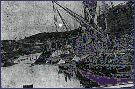 summer
of 1925, we made a survey of the U.S. Naval oil shale reserves bordering on the
Colorado River
in the vicinity
of Rifle, Colorado. The variation of the land heights there ranges from 3800 to
8800 feet. By using the negatives obtained, we were able to develop a
satisfactory transforming scale to meet the requirements of Alaska. As
a result of this survey we were asked to attend and present a report on our work
to the International Photogrammetric Conferences in Switzerland and Germany.
summer
of 1925, we made a survey of the U.S. Naval oil shale reserves bordering on the
Colorado River
in the vicinity
of Rifle, Colorado. The variation of the land heights there ranges from 3800 to
8800 feet. By using the negatives obtained, we were able to develop a
satisfactory transforming scale to meet the requirements of Alaska. As
a result of this survey we were asked to attend and present a report on our work
to the International Photogrammetric Conferences in Switzerland and Germany.
Only
two of the planes were used for mapping. The third was equipped with a radio
and, with a pilot, was kept on the beach, in readiness to institute search for
any plane that might fail to return to the base within 45 minutes of its
schedule. Prior to the departure of a plane for a flight, the exact area,
courses, and routes were laid down on flight lines over the chart so that the
position of a missing plane could be fairly well approximated, in the event it
became necessary to search for it. All planes carried emergency rations for five
days, guns, ammunition, fishing tackle, smoke flares and homing pigeons in case
of a forced landing. Fortunately, it was not necessary to resort to any of our
emergency kits since no forced landing from any cause whatsoever occurred.
Not
all of our time was spent in work. There were fishing and hunting trips. The
mountains of Alaska abound in big game and constitute a hunter’s paradise. The
Alaska Brown Bear is said to be the fiercest flesh-eating animal in North
America. This, no doubt, would be a pleasant thought to the pilot and crew as
they were plodding their weary way homeward after having been forced to land by
motor failure on a snow-clad mountain peak a hundred miles or so from their
base. Our contact with the bears, however, was not limited to the stories told
us by the natives. The sentry standing watch on the planes one night looked up
from his fishing and suddenly discovered a husky fellow making inroads on his
catch. When questioned later he was unable to state whether the intruder was a
black or a brown bear. He didn’t wait to see.
Of
fish there were plenty. Captain Spear on his last fishing party brought back 300
good-sized trout. For my part, however, I felt that if some local Burbank should
cross the fish with the mosquitoes I should stand a better chance of getting a
bite.
The
Alaskan mosquitoes are industrious, ambitious, and successful. There is also
another pest, in the nature of a gnat, which inhabits the woods and is so small
that the Indians call them "No See ‘Ems." Many of my shipmates,
being men of intelligence and reason, believe only what they see, but I,
intelligent or not, believe in them.
 Little did I know that my encounter with the
mosquitoes and gnats in Alaska was merely a training course for the experiences
to follow. Soon and
operation of their aviation activities we engaged in photographic surveys
extending from the Pacific coast across the Andes and to the upper headwaters of
the Amazon River and along the river to Iquito’s. Throughout all this region,
the steaming tropical jungles were infested by the malarial mosquito and every
pest that flew, ran, crawled or swain.
Little did I know that my encounter with the
mosquitoes and gnats in Alaska was merely a training course for the experiences
to follow. Soon and
operation of their aviation activities we engaged in photographic surveys
extending from the Pacific coast across the Andes and to the upper headwaters of
the Amazon River and along the river to Iquito’s. Throughout all this region,
the steaming tropical jungles were infested by the malarial mosquito and every
pest that flew, ran, crawled or swain.
Then,
during WW II with our Pacific carrier groups in the Guadalcanal area and later
as Commander of the Central Pacific Islands, I engaged in a combination mosquito
and pest contest—in which, despite the advent of DDT and all its allies, the
mosquitoes emerged victorious. So, today, as we did in Alaska, I reaffirm my
belief in the might of the mosquito.
Much
time was lost owing to low clouds and rain. An aerologist attached to the
expedition kept a weather log, prepared a daily weather chart, and issued
forecasts. However, the aerologist met with keen competition in the matter of
forecasting weather. The native Indians have considerable weather lore, which
they fall back upon when forecasting. One of the old Indians who frequented the
operating beach was very accurate in his estimates. He claimed that the ravens
change the tone of their cry with a change of the weather. Another one told us
that when the sea gulls come in and hover over the mountain the winds are going
to be strong from the southeast and will bring rain.
Many
of the steamship captains have given up the hope of forecasting the weather and
close the question by saving "You never can tell." Experience with the
weather chart, however, has indicated that it is just as easy to forecast
weather along the southeastern section of Alaska as it is elsewhere along the
Pacific Coast. Certainly the forecaster will make a far better record than the
average, should he forecast daily, "Rain today and tomorrow."
From
Ketchikan we worked our way northward, shifting our bases as the necessity
arose, taking in the entire area from the International Boundary on the south to
the Canadian Boundary on the east and the Pacific on the west. At times the
weather was discouraging - it seemed that it would never stop raining. When the
weather was clear much progress could be made. Our average day’s work for two
planes was better than 1000 square miles. On two successive days, 1600 square
miles each day were surveyed.
As
one area was finished the Gannet would
tow the barge and supplies to our next base. The planes as a rule would proceed
with mapping and, upon completion of the work, fly to the newly selected base.
Obtaining gas and supplies was quite a problem. While engaged in mapping, the
planes consumed more than 600 gallons of gasoline per day. When the good weather
did arrive, it usually lasted for about ten days, so that our plans had to be
laid well in advance to prevent any delay in mapping operations.
We
were fortunate that not one day of mapping weather was lost for any cause
whatsoever—nor was any plane out of commission when it could have been used
for mapping.
During
our summer’s work many new lakes were discovered—the power of which no doubt
will be used to turn the wheels of industry when the time comes to develop the
tremendous resources of Alaska. Millions of acres of invaluable timber were
brought to light—timber for the manufacture of pulp and paper—and much
airplane spruce. The famous and treacherous waters of the Chickamin River, down
whose shores have washed the richest and most valuable gold deposits in America,
were thoroughly explored and mapped.
We
surveyed the chain of glaciers throughout the northern rim of the Alexander
Archipelago whose great ice caps tower upward to heights as great as 15,000 feet
and end abruptly in great precipices miles in width and hundreds of feet high at
the water’s edge. These great glaciers are remnants of the Glacial Age. Some
are still alive today—moving slowly but surely a few feet a day, throwing off
huge icebergs, which fall into the sea with the roar of thunder.
In
our crew we were fortunate to have Mr. Sargent, a representative the Department
of the Interior. He was a gentle, quiet man of wisdom and understanding. Being
the oldest in Our Crew, he was our counselor and advisor; in return lie received
our thanks and respect.
To
him there was no task too difficult, no mountain too high to climb, no glacier
too slippery to scale. As we worked northward in our survey he constantly
reminded me that we should "cover Glacier Bay and get some scaled photos of
Muir Glacier and Mount Fairweather," which rose at the base of Muir Glacier
at the head of Glacier Bay and continued on to the westward slope where it sank
into the Pacific.
Mount
Fairweather is the southern extremity of the northwestern mountain range
extending from Glacier Bay in the south to the Seward Peninsula in the north.
This range forms the western barrier of the North American continent where the
storms that sweep with violence out of the Bering Sea set their course en route
to the United States mainland.
Mount
Fairweather rises to a height about 15,000 feet. Our planes, lightly loaded,
could reach 15,000 feet at most. "how, then, Mr. Sargent, can we make a
scaled photo of Mt. Fair-weather?" we asked.
"Let
us go to the laboratory and work out a method," lie said. "At any
rate, let us try it." And try it we did. Our efforts repaid its by the
results obtained. They incidentally led to the discovery of what was later
termed ‘‘the Preglacial Forest.’’ I believe it of sufficient interest to
describe briefly its discovery.
Our
interest in the survey was the Glacier and the upper slopes of the mountain on
the southern exposure. The normal wind, which brings fair weather in that area,
was from the northwest. What we needed was a southeast wind to give us the
upward flow of air on the south side. A southeast wind, however, brought clouds,
which prevented photography.
A
detailed study of the weather conditions indicated that a period of five hours
of clear weather might well prevail after the reversal of the wind currents from
northwest to southeast. With the weatherman embarked on our tender, the Gannet,
anchored in Glacier Bay, we were lucky in our calculations and arrived on
location with a fair southeast wind and clear skies.
We
flew a carefully measured zigzag course from the end of the glacier at the head
of the bay and gradually role upward on the rising air currents until we had
covered the entire southern section.
When
we developed the negatives, an examination of our prints showed occasional black
spots at irregular intervals along the entire lower section of the glacier. This
interested all of us.
Mr.
Sargent, after studying many pictures, said to us: "These are trees,
that’s what they are!" "Well, let’s say they are trees, what of it
?" I countered. "I’ve seen igloos covered with snow and ice."
"But, Ben, you don’t realize that the snow and ice of that glacier have
been there for a million years or more—and those trees, if trees they are,
were there growing before the glacier was formed.
"These
glaciers are remnants of the second Glacial Age. Most are dormant as this one
and gradually disintegrated - and maybe we have discovered a forest, which, if
so, is a ‘Pre-Glacial Forest.’ "
"All right, Mr. Sargent—what do we do about it?"
"We
send an expedition in there to examine it and find out about it."
"O.K.,
it’s your project. Name your leader, pick your men, outfit them, and we’ll
settle this argument."
We
did. Mr. Sargent led a group of hale and hearty young men (he was, I presume,
around 50), and returned with sections of logs from the "PreGlacial Forest
of Glacier Bay" which are "more than one million years old."
The
trees are not petrified; but preserved in their natural form with the snow and
ice that fell and froze during the "second glacial age." My souvenir
is a small section of a log said to be of the pine family, and it is still well
preserved.It is my understanding that the Smithsonian Institution has some of
Sargent’s samples and that lie turned a report of the "Pre-Glacial
Forest" into the Institution.
On
the island of Revillagigedo, a valley and low pass were discovered which in the
opinion of Charles H. Florey, the Alaskan District Forester, will permit the
linking up of all the important water power sites of Revillagigedo with the
mainland and deliver more than 85,000 horsepower to the city of Ketchikan.
Our
work, aside from proving the feasibility of surveying by aircraft, was an acid
test on the airplane itself, and it proved its ability to operate for long
periods of time away from the home base under the most severe climatic
conditions and with little or no protection from rains, storms, and seas. After
the completion of the summer’s work, the planes were flown back to San Diego
and were ready to begin operations with the Fleet on the day of their arrival.
The
dramatic, eternal landscape of Alaska, the rugged, forbidding, snowcapped
mountains, suddenly and abruptly turning to the calm and glistening emerald of
an ocean inlet, the furious and fast moving billowing clouds that suddenly burst
with torrential rain or snows, followed by the rainbow that reveals the
landscape in all its glories of ageless ice and snow - all of these we well
remember. However, indelibly engraved upon our thoughts is the cordial
friendship we received a comforting and enduring gift of the people of Alaska.
In
September, 1935 the second Alaskan Aerial Survey expedition was sent to Dutch
Harbor in the Aleutians to do Additional aerial mapping of uncharted areas.